Trail Walking La Ciotat - La Grande Arche depuis la Ciotat - Photo
 tracegps
tracegps

User

© OpenStreetMap contributors
Length
Length
8.9 km
Max alt
Max alt
380 m
Uphill gradient
Uphill gradient
443 m
Km-Effort
Km-Effort  
14.8 km
Min alt
Min alt
126 m
Downhill gradient
Downhill gradient
443 m
Boucle
Boucle
Yes
Creation date :
2014-12-10 00:00:00.0
Updated on :
2014-12-10 00:00:00.0

(1 Reviews)

Walking
Walking
3h45
Difficulty : Medium

Scan this QR Code to open this trail in the SityTrail application

FREE GPS app for hiking

Logo SityTrail SityTrail

IGN / Geographical institutes

Download SityTrail from the App Store Download SityTrail from Google Play

Logo SityTrail SityTrail World

The world is yours!

Download SityTrail from the App Store Download SityTrail from Google Play Download SityTrail on Huawei AppGallery

About

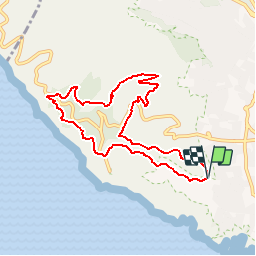
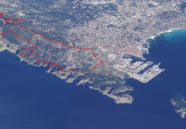
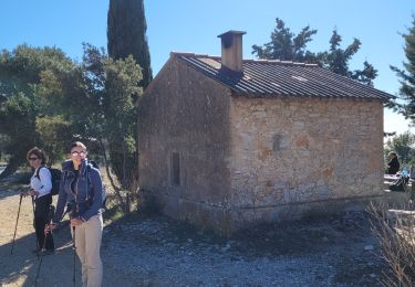
Trail Walking of 8.9 km to be discovered at Provence-Alpes-Côte d'Azur, Bouches-du-Rhône, La Ciotat. This trail is proposed by tracegps.

Description

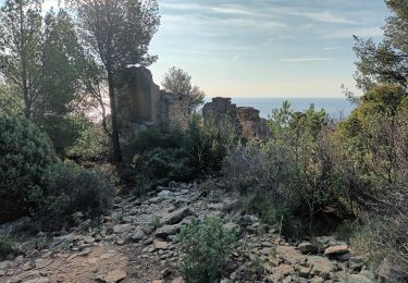
Depuis Cante-Coucou, quartier de la Ciotat, la Grande Arche et la Dent de Chat sont le but d'une randonnée intéressante qui emprunte un vieux sentier pour traverser la Grande Tête avant de descendre sur Fardeloup, puis le stand de tir. Une montée agréable par Mallombre, la Tête de Chat et la Grande Arche rejoint le chemin de crête des Falaises Soubeyranes. Après le Sémaphore du Bec de l'Aigle, c'est encore un vieux passage presque oublié qui rattrape le Chemin de la Vigie pour retrouver le point de départ. Description complète sur sentier-nature.com : La Grande Arche, depuis la Ciotat Avertissement [Exposition 1/3]. Certains passages de cet itinéraire de montagne sont escarpés et/ou exposés, il est déconseillé aux enfants non accompagnés et aux personnes sujettes au vertige.

Elevation profile

Photos

Positioning

Country:
France
Region :
Provence-Alpes-Côte d'Azur
Department/Province :
Bouches-du-Rhône
Municipality :
La Ciotat
Location:
Unknown
Start:(UTM)
710607 ; 4783409 (31T) N.

Comments

Please log in to post a review or rate the element


Trails nearby

Trail Road bike Cassis - 7909608-TRIMRS2017_Parcours Bike L V5 - Photo
Road bike
GUIDE+

Road bike

Medium
(1)
Cassis, Provence-Alpes-Côte d'Azur, Bouches-du-Rhône, France
21 km | 26 km-effort
1h 31min
No
Trail Walking La Ciotat - Rando Ciotat - Photo
Walking
GUIDE
affinetataille

Walking

Difficult
(1)
La Ciotat, Provence-Alpes-Côte d'Azur, Bouches-du-Rhône, France
12.1 km | 19.9 km-effort
7h 30min
Yes
Trail Walking La Ciotat - la ciotat - Photo
Walking
Berrangerannick

Walking

Very easy
(1)
La Ciotat, Provence-Alpes-Côte d'Azur, Bouches-du-Rhône, France
6.2 km | 9.3 km-effort
3h 21min
Yes
Trail Walking Cassis - les calanques de Cassis - Photo
Walking
th.feur

Walking

Medium
(1)
Cassis, Provence-Alpes-Côte d'Azur, Bouches-du-Rhône, France
15.9 km | 23 km-effort
6h 2min
No
Trail Walking Cassis - calanques 1 - Photo
Walking
lionel4806

Walking

Difficult
(1)
Cassis, Provence-Alpes-Côte d'Azur, Bouches-du-Rhône, France
14.6 km | 26 km-effort
5h 37min
No
Trail Walking La Ciotat - Cap Canaille - Photo
Walking
DanielROLLET

Walking

Medium
(1)
La Ciotat, Provence-Alpes-Côte d'Azur, Bouches-du-Rhône, France
10.2 km | 16.2 km-effort
4h 0min
Yes
Trail Walking La Ciotat - Sémaphore bec de l'Aigle, la Ciotat, 04-10-23  - Photo
Walking
Christiancordin

Walking

Medium
La Ciotat, Provence-Alpes-Côte d'Azur, Bouches-du-Rhône, France
13 km | 19.6 km-effort
3h 53min
Yes
Trail Walking La Ciotat - La Ciotat Cassis par la falaise cap canaille  - Photo
Walking
GUIDE
antignacs

Walking

Easy
La Ciotat, Provence-Alpes-Côte d'Azur, Bouches-du-Rhône, France
7.6 km | 14 km-effort
3h 47min
No
Trail Walking Ceyreste - les cabanons des gardes et du marquis - Photo
Walking
GUIDE
amiral13

Walking

Easy
Ceyreste, Provence-Alpes-Côte d'Azur, Bouches-du-Rhône, France
12 km | 18.1 km-effort
5h 9min
Yes


Close
My subscriptions